


Location: Cement Creek Area
Date of Observation: 01/10/2015
Weather: Sunny, blue skies, and very warm. No wind.
Snowpack: BTL-Large surface hoar forming (5 to 7.5 cm). Observed several rollers on southerly aspects.
Snodgrass
Location: Crested Butte Area
Date of Observation: 01/09/2015
Elevation: BTL/NTL
Weather: Sunny, very warm, and no wind
Snowpack: BTL and NTL-Surface hoar on all aspects up to 2.5 cm. Observed one SS-D0.5 on road cut. slab was 18 inches deep and failed on facets. Didn’t see a post on observations and didn’t see a ski cut on the slope. This failure was on one of the road cuts.
Uploads:
Mountain Weather for Saturday, January 10th, 2015
Date: 01/10/2015
Another cold, calm morning before temps rise into the low 30s today, ahead of a small disturbance after midnight which should bring us a much needed coat of fresh paint for the hills. This first storm will clear out the inversions and prime the pump for a more significant storm Monday and Tuesday. Winds should remain light with this weak, mild storm, and most areas should pick up 2-4.” We’ll take it.
Today
High Temperature: 30-35
Wind Speed: 5-15
Wind Direction: W
Sky Cover: Mostly Cloudy
Snow: 0-1″
Tonight
Low Temperature: 15-20
Wind Speed: 5-15
Wind Direction: W
Sky Cover: Increasing clouds
Snow: 1-3″
Tomorrow
High Temperature: 20-25
Wind Speed: 5-15
Wind Direction: W
Sky Cover: Mostly Cloudy
Snow: 1-2″
Spring Creek, Taylor Canyon
Name: Ian Havlick
Title: Spring Creek, Taylor Canyon
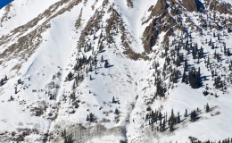
Location: Cement Creek Area
Date of Observation: 01/09/2015
Aspect: North, South, North West
Elevation: 8500-9500
Avalanches: Size 1 Wet loose avalanches scouring to ground from rapid warm up a few days ago, even on NW facing slopes. Steep, but northerly. Would not have buried a person, but could have caused injury if in wrong place at wrong time.
Weather: Partly cloudy, mild, no wind
Snowpack: Shallow snowpack, less than 45cm deep, all facets. no sign of significant wind loading. slight temperature/suncrust, with 3-4mm surface hoar above. No pits or stability tests performed.
Uploads:
Washington Gulch/Conies
Name: Irwin Guides (CBMG)
Title: Washington Gulch/Conies
Location: Crested Butte Area
Date of Observation: 01/09/2015
Aspect: North East, East, South East
Elevation: 9400-11600
Weather: WEATHER: Clear, Light West wind on ridge, no temps observed.
Snowpack: SNOWPACK/AVALANCHE OBS: Large surface hoar on top of facets, with a thin, supporting mid-pack, over basal facets. Significant whumpfing in valley bottom; but no signs of instabilities observed on slopes up to 35º.
Washington Gulch
Name: Evan Ross
DATE: 1/09/15
LOCATION: Crested Butte Area
ASPECT: E, NE
Elevation: Valley Bottom, 9,500ft
WEATHER: Sunny and warm. No wind.
SNOWPACK/AVALANCHE OBS: Low angle near Washington Gulch TH. Plenty of collapsing without any cracks. Variable slab strength with ski pen at 10cm during the good times and ski pen on the ground during the bad times. Boot pen would have been to the ground all the time. The low elevation slab has certainly been faceting out at these low elevations but the question is how much longer will it take for the slabs to become isolated? HS 60-80cm. Lots of large surface hoar in the valley. SS-N-R1-D2-O at 12,300ft on south aspect of Baldy. Likely failed around Jan 4th and originally observed on Jan 5th.
Loose snow avalanche that propagated a shallow slab 100ft wide below Gothic Spoon at 11,300ft, D2. Likely failed Jan 6th and originally observed on the 7th.
-
- Loose snow avalanche that propagated a shallow slab below Gothic Spoon at 11,300ft, D2. Likely failed Jan 6th and originally observed on the 7th
-
- SS-N-R1-D2-O at 12,300ft on south aspect of Baldy. Likely failed around Jan 4th and originally observed on Jan 5th
Anthracite Surface Hoar
Name: Alan Bernholtz
Title: Anthracite Surface Hoar
Location: Kebler Pass Area
Date of Observation: 01/09/2015
Elevation: BTL
Uploads:
-
- click to enlarge
Mountain Weather for Friday, January 9th, 2015
Date: 01/09/2015
A big arctic airmass will droop into the Midwest today, but terrain will block that cold air from western Colorado, and we will only see slightly cooler temperatures today, with partly cloudy skies once again. Tomorrow night it all gets a little more interesting with an appetizer of snow before another, stronger wave of moisture on Monday.
Today
High Temperature: 30-35
Wind Speed: 5-15
Wind Direction: W
Sky Cover: Clear
Snow: 0″
Tonight
Low Temperature: 10-15
Wind Speed: 5-15
Wind Direction: SW, W
Sky Cover: Partly Cloudy
Snow: 0″
Tomorrow
High Temperature: 30-35
Wind Speed: 5-15
Wind Direction: W
Sky Cover: Increasing clouds
Snow: 0-1″
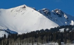
Washington Gulch
Name: Irwin Guides (CBMG)
Title: Washington Gulch
Location: Crested Butte Area
Date of Observation: 01/08/2015
Aspect: North East, East, South East
Elevation: 9500-11000
WEATHER: Clear skies, hot in the sun, no wind in valley, light winds from NW on ridge top.
Snowpack: SNOWPACK/AVALANCHE OBS: Huge surface hoar growth from valley floor to ridge top. Overall snowpack very weak and unconsolidated. HS average of 60cm valley floor and 120cm at ridge top. Lots of big collapses observed on bottom 1/2 of terrain both on up track and on egress out. These seemed to become widespread and predictable the minute the snowpack structure lacked any cohesive ‘mid-pack’. Upper 1/3 of terrain was characterized by a snowpack structure that was slightly more supportive with ski pen about 20cm. Here quick test profile pits revealed a small (15cm thick) 4F+/1F- hard layer about 40cm below the surface capping the Dec 13th interface and the basal facets. Hand shear tests and compression tests both showed moderate failures on the basal facets directly below this layer The middle 1/3 is the scary tapering thickness persistent slab problem pointed out in CBAC report (0-15cm thick) where skier triggering is likely to occur.
Uploads:
Park Cone Above Taylor Reservior
Name: Ian Havlick
Title: Park Cone near Taylor Reservior
Location: Cement Creek Area
Date of Observation: 01/08/2015
Aspect: North, North East
Elevation: 9400-11600
Avalanches: only avalanches observed were D1.5 WL slides across SE-S-SW facing slopes across Collegiates and off Matchless Mtn. All originated in steep, rocky or krumholtzy terrain.
Weather: Clear, calm, mild.
Snowpack: Snowpack depth varied from ~65cm to 155cm in wind loaded areas near treeline. Constant collapsing as we broke trail all day. Every step would collapse between the TH at 9400 til we broke onto more open, wind effected slopes near treeline. Some collapses were booming, and rolling, many were localized around each ski. Treebombed snow surfaces added support and structure and helped ascent. Many times ski pen would be 10-15cm, then suddenly drop knee deep into the snowpack…example of variable structure and slab.
Uploads: