Mountain Weather February 25, 2015

CB Avalanche CenterWeather

Date: 02/25/2015

Unsettled northwest flow is developing over Colorado. A few pulses of moisture through the rest of the work week will bring the chance for light snow each day and increased wind speeds. We are too far south and west to catch major accumulations, but a larger storm is brewing for the weekend, which has some similar traits as last weekend’s storm.

Mt. Owen

CB Avalanche Center2014-15 Observations

LOCATION: Kebler Pass Area
DATE OF OBSERVATION: 02/24/2015
SUBJECT: Mt. Owen
ASPECT: North, North West
ELEVATION: 13000 feet


AVALANCHES: Skier triggered storm slab. Broke 1 foot deep propagated 100 feet on steep, shady alpine terrain and ran 1000 feet

WEATHER: clear calm

SNOWPACK: 10-14 inches of new snow, now wind.

UPLOADS:

avy

snow surveys

CB Avalanche Center2014-15 Observations

LOCATION: Crested Butte Area
DATE OF OBSERVATION: 02/24/2015
NAME: ADB
SUBJECT: snow surveys
ASPECT:
ELEVATION:


AVALANCHES: Numerous slides observed on Axtell and Happy Chutes. Most of the slides were soft slab. Damage scale was mostly D1 with some D2. Aspects where activity occurred was from NE to E.

WEATHER: Mostly sunny. calm. Hot

SNOWPACK: Snow survey depths for Red lady Glades: 25 to 35.5 inches for 5 measurements.
Snow Survey depth for Butte: 25 to 42.5 inches for 12 measurements

UPLOADS:

Gothic snow and avalanche obs

CBAC2014-15 Observations

Only 1″ new snow with very light snow Monday morning and after dark, then clear and cooler than it has been (-03ºF).  Snowpack settled from 48″ to 45½” now.

There were a number of point releases off steep slopes but also 4 one  foot fractures on Snodgrass starting at various elevations, all small but a couple running about 400 feet or so.

Recent Natural Avalanches along Kebler Pass Road

CB Avalanche Center2014-15 Observations

LOCATION: Kebler Pass Area
DATE OF OBSERVATION: 02/24/2015
NAME: Zach Guy
SUBJECT: Recent Natural Avalanches along Kebler Pass Road
ASPECT: North, North East, East, South
ELEVATION:


AVALANCHES: Good view of recent avalanche cycle from the weekend’s storm. About a dozen soft slabs, D1 to D1.5’s, failing at the storm interface on northwest to east-northeast aspects. (Several on Mt. Axtell, Carbon Peak, East bowl in the Anthracites, Northwest bowl in the Anthracites, above Coal Creek, and in the Anthracite Range). Most of these were near/below treeline, and two were above treeline near Ohio Peak. Two notable slides had larger crowns, and looked to have failed on older, deeper layers, several feet deep and D2 in size. One was a heavily crossloaded slope on Mt Axtell, NE aspect below treeline. The other was a north facing bowl below Ohio Peak. I think the latter failed today. There were dozens of dry loose avalanches, D1 in size, on various aspects, and a number of natural wet loose avalanches ran today on southerly aspects, but didn’t see any slab avalanches on these aspects in the Ruby Range or Peeler Basin.

WEATHER: Clear skies. Calm winds. High of 32 at 10k.

SNOWPACK: Snow surfaces became moist on E through S through W aspects today.

UPLOADS:

Mountain Weather February 24, 2015

CB Avalanche CenterWeather

Date: 02/24/2015

As the closed low moves west into central Arizona, we’ll see cloud cover decrease today under light winds. The pattern shifts to northwest flow through the rest of the week as a large scale trough moves across Canada, sending a series of shortwaves to our north. We’ll see cold air, increased winds, and a continued chance for snowfall into the weekend.

Red Coon Glade

CBAC2014-15 Observations, Avi Blog

NAME: Evan Ross
DATE: 2/23/15
LOCATION: Red Coon Glade
ELEVATION: 9,000-11,700ft
ASPECT: SE

WEATHER: Overcast sky was breaking up in the afternoon. A frew s-1 snow showers through out the day. Strong solar through thin clouds was creating a green housing effect. Calm wind throughout the day.SNOWPACK/AVALANCHE OBS: Green housing and some solar warmed the snow surface and created a 1-2cm crust by the afternoon. Had pits along the way found generally good bonding between the new/old snow interface as well as the new snow lacking a cohesive slab. HST at 11,000ft was 40-45cm. BTL south facing slopes grater then 30 degrees and below 10,000ft where bare of snow before this storm.

Ski cuts on a small shaded slope BTL that was about 35 degrees produced small storm slab avalanches on the old snow surface about 15 feet wide.
Observed several loose snow avalanches on a steep easterly slope near treeline that looked to set down into the facets below. These D1.5 sloughs may have failed naturally or where skier triggered from the ridge above.

Natural and skier triggered avalanches in Slate River Basin

CB Avalanche Center2014-15 Observations

LOCATION: Crested Butte Area
DATE OF OBSERVATION: 02/23/2015
NAME: Zach Guy
SUBJECT: Natural and skier triggered avalanches in Slate River Basin
ASPECT: North, North East, East, South
ELEVATION: 9,000 -11,400 ft.


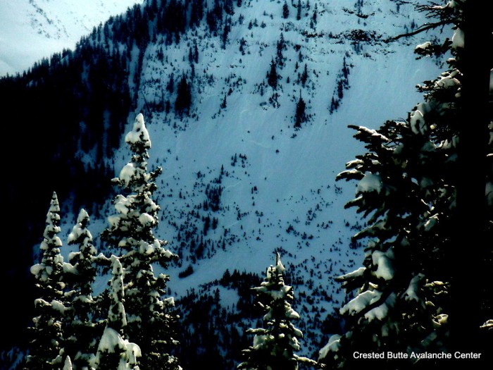
AVALANCHES: Observed ~10 natural soft slab avalanches failing on the storm interface (near surface facets) mostly below treeline and a few near treeline slopes on North and Northeast aspects. Slabs were generally 40 to 150 feet wide, 12″-16″ deep, and ran a couple hundred vertical, not large enough to bury someone. Observed slides in Schuykill Ridge, Climax Chutes, Happy Chutes, and Peeler Basin. (SS-N-R1-D1-I). One exception was a wider and longer running slide on Schuykill Ridge, maybe 300-400 feet wide and ran 1,000 vertical, D2 in size.

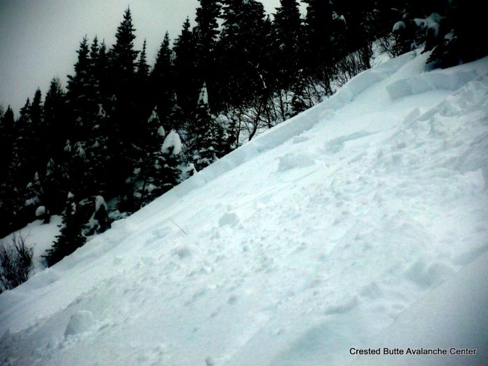
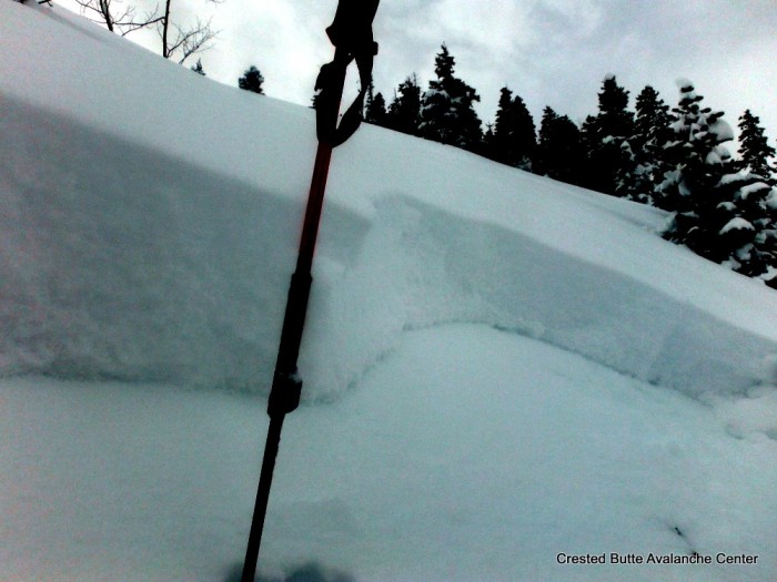
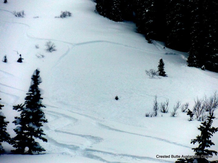
We skier triggered about 15 similar slides, all BTL on N/NE aspects on Schuykill Ridge. D1 in size on relatively small terrain features. Slides behaved like storm slabs in that they didn’t propagate beyond the steep rollovers and wouldn’t trigger remotely.

WEATHER: Overcast to broken skies. Calm winds. Very light snowfall (S-1) tapered by 10:00 a.m. Mild temperatures.

SNOWPACK: 12″ to 16″ of fist hard storm snow, zero wind affect. Formed a soft slab over widespread near surface facets on N/NE, thin crust over facets on E, and thick crust on S. Storm snow was very reactive anywhere that it was on near surface facets. Widespread shooting cracks up to 100 feet, some collapsing, and anything over 36 or 37 degrees was almost a sure bet it would slide. No signs of instability on south aspects and got one collapse on an east aspect, under the thin crust. Below the storm slab, the snowpack was faceted throughout, and didn’t feel persistent slab structure, even near ridgetop. However, we didn’t poke around under the large, windloaded start zones that are likely to be holding stronger mid or upper pack.

UPLOADS:
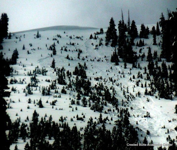
DSCF5603-001

Schuykill Ridge. NE aspect  SS-N-R1-D1-I
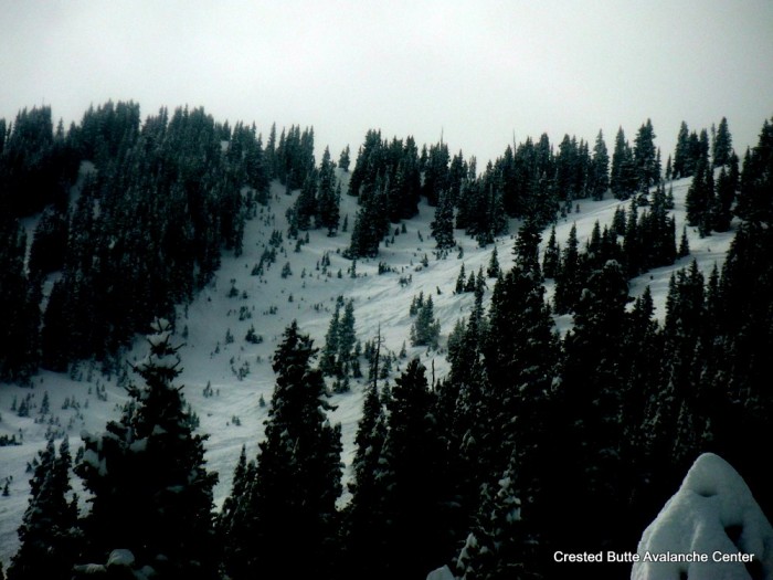
 

DSCF5604-001

Schuykill Ridge, NE aspect.  SS-N-R2-D2-I
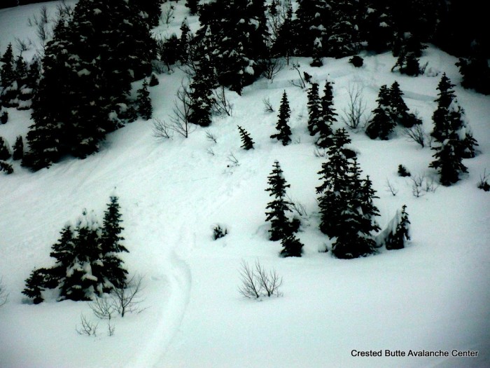
DSCF5605-001

Skier triggered soft slab.  Schuykill Ridge. N or NE aspect BTL
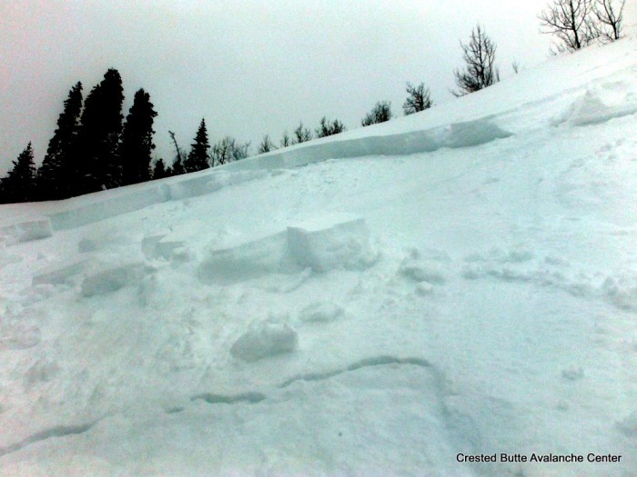
DSCF5610-001


Skier triggered soft slab.  Schuykill Ridge. N or NE aspect BTL
DSCF5612-001

Skier triggered soft slab.  Schuykill Ridge. N or NE aspect BTL
DSCF5613-001

Skier triggered soft slab.  Schuykill Ridge. N or NE aspect BTL
DSCF5615-001

Natural soft slabs on Peeler Peak.  SS-N-R1-D1-I
DSCF5618-001

Skier triggered soft slab.  Schuykill Ridge.  NE aspect BTL