
Mountain Weather
Date: 04/05/2016
A low pressure system is descending on Colorado today from the northwest. Mild temperatures, increasing winds, and mostly cloudy skies are on tap today until a weak cold front pushes through this afternoon. We could see a few inches of new snow as this system moves through, followed by high pressure and warming temperatures quickly rebuilding tomorrow.
Today
High Temperature: 40
Wind Speed: 15-25, G45
Wind Direction: W, NW
Sky Cover: Mostly Cloudy
Snow: 1-3″
Tonight
Low Temperature: 20
Wind Speed: 10-20
Wind Direction: NW
Sky Cover: Partly Cloudy
Snow: 0-1″
Tomorrow
High Temperature: 40
Wind Speed: 10-20
Wind Direction: NW
Sky Cover: Mostly Clear
Snow: 0
Mt. Emmons
Location: Crested Butte Area
Date of Observation: 04/04/2016
Name: Zach Guy
Date of Observation: 04/04/2016
Name: Zach Guy
Subject: Mt. Emmons
Aspect: North, North East, South East
Elevation: 9,100-12,100 ft
Aspect: North, North East, South East
Elevation: 9,100-12,100 ft
Avalanches: No signs of instability observed except skier triggered pinwheels on ENE aspects NTL and a handful of wet loose that ran sometime in the past three days on various sunbaked slopes, uncertain of their timing.
Weather: Very warm, moderate SW wind, few clouds increased to broken through the day.
Snowpack: Freewater accelerating deeper into the snowpack, with unsupportive wet grains observed on SE NTL and E/ENE BTL this afternoon (Boot pen was knee to waist deep in wet snowpack).
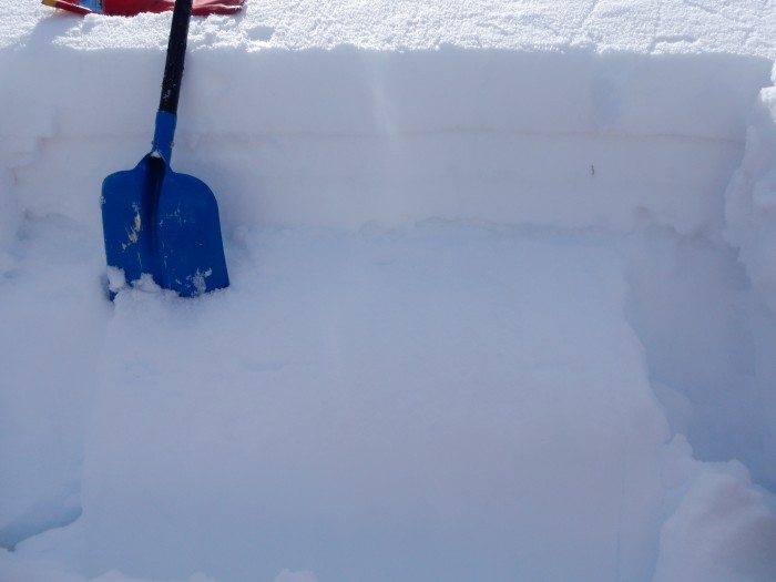
Targeted profiles on suspect persistent slab slopes showed variable results on the March 6th facet layer below a faceting or wetting slab. See photo captions below for profile/test results.
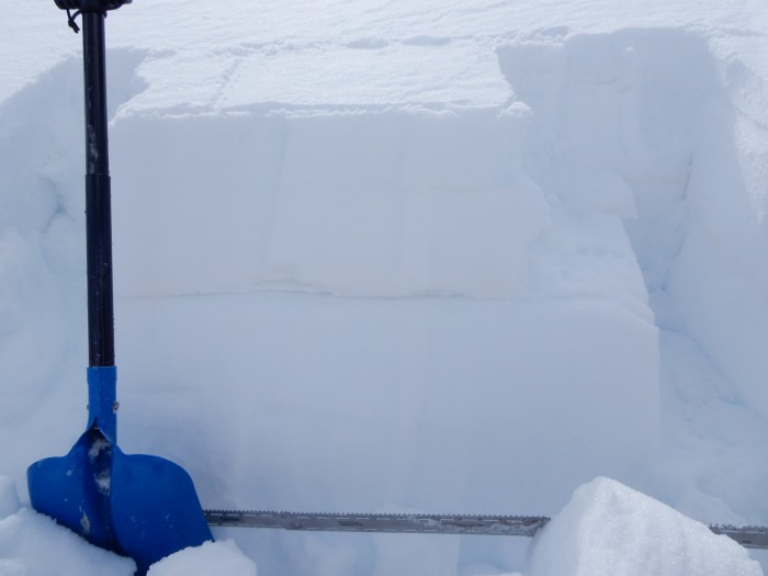
Coon Basin, NE aspect Near treeline. 35 cm, 4F+ slab over thin crust with rounding facets above and below. ECTN17 on 1.5mm rounding facets below the crust.
Climax Chutes. NNE aspect near treeline. 42 cm, 4F faceting slab over 1.0 mm, 4F- rounding facets. ECTN 28 on this layer.
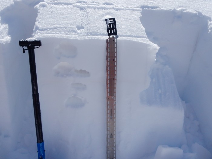
Crown profile of skier triggered avalanche last week in Climax Chutes. ENE aspect NTL. 38 cm wet (top 15cm) to moist slab over 1.5mm F+, dry rounding facets, capped by a thin crust in places. ECTP19, SC. Water pooling along upper dust/crust layer, 15 cm deep.
Looking east across the crown of the skier triggered slide in Climax Chutes last week.
Persistent Slab
Location: Crested Butte Area
Date of Observation: 04/04/2016
Name: Dustin E
Date of Observation: 04/04/2016
Name: Dustin E
Subject: Persistent Slab
Aspect: North, North East, East, North West
Elevation: 11,300
Aspect: North, North East, East, North West
Elevation: 11,300
Avalanches: None.
Weather: Clear, calm, and warm.
Snowpack: Wanted to investigate the persistent slab on NE slopes. Dug two pits on similar aspect and same elevation, second pit was more NNE facing than NE. HS varied between 85-115 cm, this area is rather rocky though. Two distinct dust layers present around 20 and 40 cm below snow surface. ECTP 13 sudden collapse on the NE slope, breaking on the prominent dust layer 40 cm below and ECTP 9 Sudden collapse on the NNE slope, breaking on the same layer. Videos to come on facebook.
Spring Season Operations
The CBAC will continue forecasts through Sunday, April 17th. Stay informed before you head out!
Mountain Weather
Date: 04/04/2016
Our high pressure gets pushed eastward today as a low pressure trough sags towards Colorado tomorrow. Today will be even warmer than yesterday. Clouds will begin to increase by late afternoon, and winds will strengthen ahead of this arriving system. Tuesday’s storm doesn’t look too impressive, with a couple of inches of new snow in the forecast before high pressure rebuilds again through the rest of the week.
Today
High Temperature: 43
Wind Speed: 5-15, G25
Wind Direction: SW, W
Sky Cover: Partly Cloudy
Snow: 0
Tonight
Low Temperature: 28
Wind Speed: 10-20
Wind Direction: SW
Sky Cover: Mostly Cloudy
Snow: 0
Tomorrow
High Temperature: 38
Wind Speed: 15-25, G40
Wind Direction: W, NW
Sky Cover: Mostly Cloudy
Snow: 0-2″
Mountain Weather
Date: 04/03/2016
Warm, dry weather continues today, with temperatures a few degrees warmer then yesterday and generally light winds. An incoming low pressure trough will bring increasing clouds on Monday, before passing to our north on Tuesday. We should pick up a couple inches of snow on Tuesday but nothing to significant. Then high pressure rebuilds for a couple days around mid-next week as many locals likely head to the desert.
Today
High Temperature: 37
Wind Speed: 3 to 13
Wind Direction: NW
Sky Cover: Mostly Clear
Snow: 0
Tonight
Low Temperature: 24
Wind Speed: 0 to 10
Wind Direction: W
Sky Cover: Mostly Clear
Snow: 0
Tomorrow
High Temperature: 40
Wind Speed: 5 to 15
Wind Direction: SW, W
Sky Cover: Increasing clouds
Snow: 0
Wet Loose in Ruby Range
Location: Kebler Pass Area
Date of Observation: 04/03/2016
Name: Zach Guy
Date of Observation: 04/03/2016
Name: Zach Guy
Subject: Wet Loose in Ruby Range
Aspect: North East, East, South East
Elevation: 11,000-12,650 ft
Aspect: North East, East, South East
Elevation: 11,000-12,650 ft
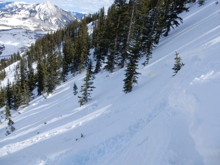
Avalanches: Numerous D1 to D1.5 natural wet loose avalanches ran today on E and SE aspects ATL, a few reaching to ENE aspects. There were several similar slides that ran yesterday on SE and S aspects ATL.
Weather: Warm temps, few clouds, light to moderate westerly wind at ridgetop
Snowpack: About 4-8″ of unconsolidated recent storm snow thawed and became moist to wet through the day. Touchy wet loose conditions (large pinwheels and pushy snow) on east aspects around 10:30 a.m., and on SE aspects by 11:30 a.m. Steep NE aspects felt dry, while moderate to low angle pitches on the same aspect were moist.
Natural wet loose avalanches off of SE face of Afley Peak
Scarp Ridge NE Natural
Location: Kebler Pass Area
Date of Observation: 04/03/2016
Name: Alex Banas
Date of Observation: 04/03/2016
Name: Alex Banas
Subject: Scarp Ridge NE Natural
Aspect: North East
Elevation: 12,000
Aspect: North East
Elevation: 12,000
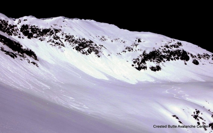
Avalanches: One natural D2 avalanche on a NE facing slope of Scarp Ridge that is new since yesterday. In the photo you can see two ski tracks skiers right from the day before that did not trigger the slide. SS-N/AC-R2-D2-O. Estimate the crown is 18″ thick and failed above the 3/22 dust layer(?), maybe cornice triggered.
Weather: Few clouds, warm temps, calm SW winds
Snowpack:
 SCARP-2
 SCARP
SCARP