Date of Observation: 02/17/2022
Name: Eric Murrow
Zone: Northwest Mountains
Route Description: Up standard Purple Ridge track and descended from the ridge through Purple Palace.
Observed avalanche activity: Yes
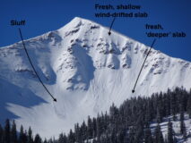
Avalanches: Observed numerous small Loose Dry avalanches on north through east aspects coming out of rocky upper elevation terrain. One fresh shallow slab immediately below a ridge top in Wolverine Basin and another deeper-looking crown on an northeasterly-facing part of the apron in Wolverine.
Weather: Partly cloudy skies in mid-morning, orographically driven cloud cover and very light snowfall midday over the spine of the Ruby Range, and clearing skies by sunset. Moderate northerly winds with stronger gusts through 1pm shifting to the northwest later in afternoon.
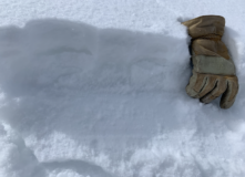
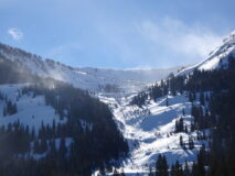
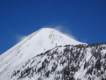
Snowpack: New snow accumulations maxed out at 5 inches on Purple Ridge near treeline. North to northwest winds transported snow throughout the day in the Ruby Range onto east through south aspects at upper elevations. At ridgetop, I was able to get some ski-length cracking in fresh cornice formation, but drifted features up to 14 inches deep did not crack. On shaded slopes below treeline, I found the 5 inches of storm snow resting on a mix of weak facets, friable melt/freeze crusts, and supportive windboard and did not find signs of instability. It seems like there were isolated Wind Slabs up high, the potential for old hard slabs from previous winds, and sluffs on weak shady slopes, but no Storm Slab problem.
- A mix of small natural avalanches in Wolverine Basin on Mount Emmons. The ‘deeper” crown on the right likely involved some old snow. I suspect it was pulled out by a loose avalanche as it ran.
- The 5 inches of low density storm snow resting on a thin windboard.
- Northwesterly winds moving snow near treeline on Schuylkill Peak’s east basin.
- Northerly winds drifting snow on to Cinnamon Mtn’s south-facing terrain.


