Zone: Southeast Mountains
Location: West Brush Creek Road towards Coffee Pot Pass
Date of Observation: 12/07/2020
Name: Eric Murrow
Subject: West Brush Creek
Aspect: North, North East, East, South East, South, South West, West, North West
Elevation: 8,900′ – 12,250′
Avalanches: Two small loose avalanches in steep terrain below treeline. Looked like east-facing rock bands may have shed small amounts of snow from solar warming onto slopes below.
Weather: Gorgeous. Mild air temperatures with very little wind below ridgetops. Full sun.
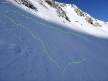
Snowpack: Shallow conditions throughout West Brush Creek. Snow volumes looked to decrease as we traveled east towards the head of West Brush Creek drainage even as elevation increased. The wind has affected most snow surfaces near and above treeline. Protected below treeline slopes that avoided the worst of the wind were around 40cm of faceted fist-hard snow. Oversnow travel was difficult and required unusual routes to stay on snow and avoid scree and bushes. There is very little terrain in this area that is viable for downhill recreation…so we just went for a tour following the valley bottom to document snow coverage in the area. Most terrain was well faceted with thin windboards capping the surface on slopes near and above treeline. We got one mentionable collapse of a 2-3 inch thick, pencil-hard windboard sitting on fist-hard 1-1.5mm facets at 12,000′ on an east-facing feature – cracks propagated around 75 feet. Faceted snow was in the 1-2mm range on west through north through east-facing slopes and fist-hard. Southerly slopes were often melted back to dirt or melt/freeze crust sitting on the ground.
- Shaded below/near treeline terrain at lower end of West Brush Creek where you can encounter loose dry avalanche concerns.
- South side of Teocalli Mountain.
- Easterly-facing terrain, near and above treeline, in upper West Brush Creek shows signs of extensive wind texture. Thin, stiff windboard resting on fist hard facets.
- Outline of cracks from collapsing a pencil-hard windboard on about 14″ of fist-hard faceted grains


